Philadelpia Regions and Neighborhoods
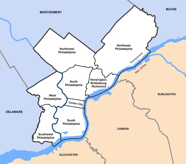
For the sake of indexing the various maps and atlases available on GeoHistory, the city of Philadelphia has been divided into regions. These regions are not "neighborhoods," but are conglomerations of city "Planning Analysis" divisions that facilitate locating appropriate materials in the collections.
Click the map for a larger view.
Philadelphia Neighborhoods
The following is a non-exhaustive list of Philadelphia neighborhoods, organized by the regional areas used by GeoHistory.
Center CityAvenue of the Arts
Callowhill
Chinatown
Elfreth's Alley
Fitler Square
Franklintown
Logan Square
Jewelers' Row
Market East
Old City
Museum District
Penn Center
Penn's Landing
Rittenhouse Square
Society Hill
South Street
Washington Square West
South PhiladelphiaBella Vista
Devil's Pocket
Dickinson Narrows
East Passyunk Crossing
Franklin Delano Roosevelt Park
Girard Estate
Greenwich
Grays Ferry
Hawthorne
Italian Market
Lower Moyamensing
Marconi Plaza
Moyamensing
Newbold
Packer Park
Passyunk Square
Pennsport
Point Breeze
Queen Village
Schuylkill
Southwark
Southwest Center City / Graduate Hospital
Sports Complex
Tasker
Wharton
Whitman
Wilson Park
West Passyunk
Southwest PhiladelphiaAngora
Bartram Village
Clearview
Kingsessing
Eastwick
Elmwood Park
Hedgerow
Hog Island
Mount Moriah
Paschall
Philadelphia International Airport
Penrose
Southwest Schuykill
West PhiladelphiaBelmont District
Black Bottom
Carroll Park
Cathedral Park
Cedar Park
Cobbs Creek
Dunlap
Garden Court
Haddington
Haverford North
Mantua
Mill Creek
Overbrook
Overbrook Park
Overbrook Farms
Parkside
Powelton Village
Saunders Park
Spruce Hill
Squirrel Hill
University City
Walnut Hill
Woodland Terrace
Wynnefield
Wynnefield Heights
|
Northwest PhiladelphiaAndorra
Cedarbrook
Chestnut Hill
East Falls
East Oak Lane
Feltonville
Fern Rock
Germantown
Logan
Manayunk
Melrose Park
Morton
Mount Airy
Ogontz
Olney
Roxborough
Upper Roxborough
West Oak Lane
Wissahickon
Wister
North PhiladelphiaAllegheny West
Brewerytown
Cabot
Fairhill
Fairmount
Francisville
Franklinville
Glenwood
Hartranft
Hunting Park
Ludlow
Nicetown-Tioga
North Central
Northern Liberties
Poplar
Sharswood
Spring Garden
South Lehigh
Stanton
Strawberry Mansion
Templetown (Temple University Area)
Yorktown
Bridesburg, Kensington, RichmondBridesburg
Fishtown
Juniata
Kensington
Olde Kensington
Port Richmond
Richmond
West Kensington
The NortheastAcademy Gardens
Ashton-Woodenbridge
Burholme
Bustleton
Byberry
Castor Garden
Crescentville
Crestmont Farms
Fox Chase
Frankford
Holme Circle
Holmesburg
Krewstown
Lawncrest
Lawndale
Lexington Park
Mayfair
Millbrook
Modena Park
Morrell Park
Oxford Circle
Normandy
Northwood
Parkwood
Pennypack
Rhawnhurst
Ryers
Somerton
Tacony
Torresdale
Upper Holmesburg
Winchester Park
Wissinoming
|
Note on Geographical Areas
Maps are tagged with the highest level area that appropriately describes the map. A map of the entire state of Pennsylvania, or a significant portion thereof, will be tagged as "Pennsylvania," not as any of the individual counties or cities shown. A map that is listed as "Philadelphia" will generally not also be listed as "North Philadelphia," even though North Philadelphia may be included on the map.
If you are doing research on a particular area of a city or state, make sure to look through resources that cover a wider range than the area you are interested in. For instance, if you are researching an area in Northeast Philadelphia, also look for citywide atlases of Philadelphia.
See Also
- Philadelphia Neighborhoods and Place Names (City of Philadelphia Archives Department)
- List of Philadelphia neighborhoods (Wikipedia)